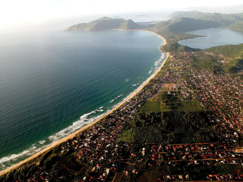
The south of the island — open ocean and wild coves. Campeche is the most dangerous beach in the state by number of drownings: 235 cases in January 2026. Matadeiro, Lagoinha do Leste and Naufragados — only on foot (Lagoinha — about 2.3 km trail from Pântano do Sul, Naufragados — 2.3 km from Caieira da Barra do Sul). Lifeguard posts are stationed on all southern beaches during the season.
Numbers on drownings are taken from the SC firefighters' statistics (afogamentos): every drowning incident is counted, including people who were rescued. This is a measure of the danger of the water, not the number of fatalities.
The south: lifeguard posts on the beaches
There is less development here than in the north, and more hills: part of the coast is parks where no roads lead. The water is colder, the waves stronger; the fishing villages Armação and Pântano do Sul are where boats and trails start.
Lifeguard posts of the Corpo de Bombeiros (CBMSC) according to the corps' table at the end of 2025:
| Beach | Posts in December 2025 |
|---|---|
| Campeche, Novo Campeche, Lomba, Areias | 12 together |
| Ilha do Campeche | 1 |
| Morro das Pedras | 3 |
| Armação | 2 |
| Matadeiro | 2 |
| Lagoinha do Leste | 2 |
| Pântano do Sul | 1 |
| Açores | 2 |
| Solidão | 1 |
| Naufragados | 1 |
Posts operate from 07:00 to 19:00; in October in the south they are at best open on weekends. Water safety rules — in Water and drownings — rip currents, beach flags, what to do.
Campeche — Praia do Campeche
District Campeche, map point -27.6860, -48.4858.
The longest beach of the south, open ocean, cold water and strong waves; in cold months right-hand waves for surfing exceed 1 meter. Sections are called Riozinho, Novo Campeche, Pico da Cruz. It ranks first for danger: 235 drowning cases in January 2026, more than any beach in the state, and 351 rescues in the 2025/2026 season. That is why there are the most posts here. Access via SC-405 and Avenida Pequeno Príncipe; bus — line 462 Campeche from the TIRIO terminal.
Ilha do Campeche
District Campeche, map point -27.6953, -48.4664.
Opposite Praia do Campeche, with a single beach on the west side and archaeological sites. A national heritage monument since 2000; from 18 Aug 2025 — protected area Monumento Natural Ilha do Campeche. Boats depart from Armação, from Campeche and from Barra da Lagoa. Visiting rules — in Day trips and weekend getaways from Florianópolis (in Russian).
Morro das Pedras — Praia do Morro das Pedras
District Morro das Pedras, map point -27.7107, -48.4995.
An open coast between Campeche and Armação, waves hit the shore directly: in July 2024 firefighters tied down a lifeguard post so it would not be overturned, and Civil Defense evacuated houses because of erosion. Out of season the post is closed. Buses — lines 473 and 474 from the TIRIO terminal.
Armação — Praia da Armação
District Armação, map point -27.7360, -48.5066.
One of the main artisanal fishing villages of the island, the name comes from an old whaling station; the church of Sant'Ana dates to 1772. More boats leave here for Ilha do Campeche than from anywhere else. In January–September 2024 — 76 drowning cases.
Matadeiro — Praia do Matadeiro
District Armação, map point -27.7544, -48.4981.
There is no road: from Armação you cross a stream from Lagoa do Peri and walk about 200 m on foot. Strong surf, a surfing spot, forested slopes. It is no calm cove: 303 drowning cases in January–September 2024, second place in the city, and 126 rescues in the 2025/2026 season. At the end of the beach a trail to Lagoinha do Leste begins.
Lagoinha do Leste — Praia da Lagoinha do Leste
District Pântano do Sul, map point -27.7739, -48.4855.
A beach with a lagoon inside the municipal park Lagoinha do Leste, 921 ha. There is no road: by trail from Pântano do Sul (about 2.3 km, shorter and steeper) or from Matadeiro (about 4 km), or by boat from Pântano do Sul. It is better to return by the same trail: going around along the shore is dangerous. This trail has ranked first in Greater Florianópolis for rescue callouts since 2016; details — in Trails, waterfalls and viewpoints of Florianópolis — length, time, difficulty. On the beach itself — 90 drowning cases in January–September 2024.
Pântano do Sul — Praia do Pântano do Sul
District Pântano do Sul, map point -27.7858, -48.5188.
A fishing village with seafood restaurants and the start of the short trail to Lagoinha do Leste. Bus — line 564 Pântano do Sul from TIRIO.
Açores — Praia dos Açores
District Pântano do Sul, map point -27.7843, -48.5231.
Between Pântano do Sul and Solidão, with views of the islands Três Irmãs and Moleques do Sul; the beach is reached by paved road, there is parking nearby. It looks calm, but in January–September 2024 there were 226 drowning cases here — fourth place in the city.
Solidão — Praia da Solidão
District Pântano do Sul, map point -27.7949, -48.5347.
A small beach about 850 m long, white sand, clear water and rough sea. Nearby is the Cachoeira da Solidão waterfall (Trails, waterfalls and viewpoints of Florianópolis — length, time, difficulty).
Naufragados — Praia dos Naufragados
District Naufragados, map point -27.8340, -48.5634.
The southern tip of the island, part of the Serra do Tabuleiro park since 1975 (Parks and reserves of Florianópolis — who manages, what is allowed, where to swim). Only by trail — about 2.3 km, about an hour, medium difficulty, from Caieira da Barra do Sul (bus 561 from TIRIO goes there) — or by boat. The sea is cold and rough. The name comes from a shipwreck of 1753: of 250 people on board 77 survived. Nearby are a lighthouse and ruins of fortifications, covered in Fortresses and historical sites of Florianópolis — forts, Ponte Hercílio Luz, old center.
Sources
- T1Corpo de Bombeiros SC, 1ª RBM — number of lifeguard posts for each beach in Florianópolis, October–December 2025portalelegis.alesc.sc.gov.br · primary source
- T1Corpo de Bombeiros SC, 1º BBM — season 2025/2026 results: rescues from rip currents by beachesportalelegis.alesc.sc.gov.br · primary source
- T2NSC Total, 4 Apr 2026 — Campeche first in the state for drownings in January 2026, data from Corpo de Bombeirosnsctotal.com.br · secondary source
- T2NSC Total, 29 Oct 2024 — drownings on Florianópolis beaches for January–September 2024nsctotal.com.br · secondary source
- T1Ministério Público Federal — Ilha do Campeche protected area Monumento Natural since 18 Aug 2025, national heritage monument since 2000mpf.mp.br · primary source
- T2NSC Total, 15 Jan 2026 — boat quotas to Ilha Campeche by piers: Armação, Campeche, Barra da Lagoansctotal.com.br · secondary source
- T1FLORAM — protected areas of the city: Parque Lagoinha do Leste, 921 ha, access by trail from Pantano do Sul or Armaçãopmf.sc.gov.br · primary source
- T2NSC Total, 6 Jul 2025 — trail to Lagoinha do Leste first in rescue calls in Greater Florianópolis since 2016nsctotal.com.br · secondary source
- T2NSC Total, 7 Feb 2024 — trails of Florianópolis with length, time and difficulty, advice from Corpo de Bombeirosnsctotal.com.br · secondary source
- T2Wikipedia — Praia do Matadeiro: access only on foot via river from Armaçãopt.wikipedia.org · secondary source
- T2Wikipedia — Praia da Lagoinha do Leste: trails 2.3 km from Pantano do Sul and about 4 km from Matadeiropt.wikipedia.org · secondary source
- T2NSC Total, 22 Mar 2024 — Naufragados: only by trail or boat, shipwreck of 1753nsctotal.com.br · secondary source
- T1Consórcio Fênix — list of bus lines by terminalsconsorciofenix.com.br · primary source
- T2OpenStreetMap and Wikidata — beach and island points on the map, © OpenStreetMap contributors, ODbLopenstreetmap.org · secondary source
T1 — primary: law, agency site, price list. T2 — secondary: press, specialist sites. T3 — other.