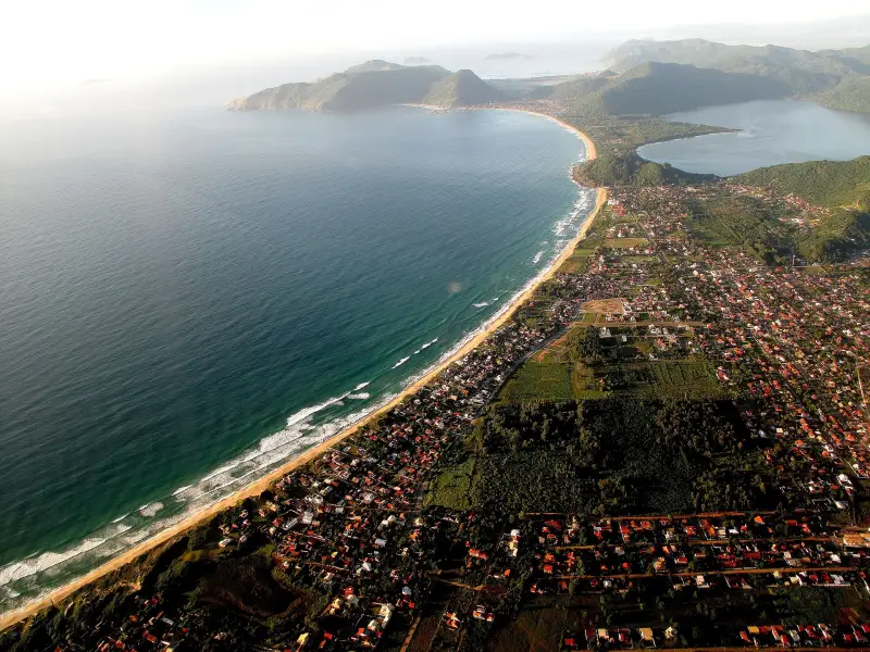
The west coast of the island and the mainland part of the city face the bays, Baía Norte and Baía Sul: there are almost no waves, but the water is more often unsuitable for bathing because of sewage discharges. In the IMA SC report of 29 Oct 2026, among others, Cacupé and Bom Abrigo were unsuitable; in November 2025 the only mainland beach that was suitable was Palmeiras. People come here for the sunset and the Azorean villages — Santo Antônio de Lisboa, Sambaqui, Ribeirão da Ilha. Before swimming, check the current status of the point on the IMA SC website.
Numbers for drownings are taken from the SC fire brigade statistics (afogamentos): this counts every drowning incident, including people who were rescued. This is a measure of the danger of the water, not the number of fatalities.
How to read water quality
IMA SC takes samples at 88 points in Florianópolis: weekly from October to March, once a month from April to September, the report is released on Fridays. A point is suitable (própria) if in four of the last five samples there are no more than 800 E. coli bacteria per 100 ml; unsuitable (imprópria) if that limit is exceeded more often or if the last sample is above 2,000. The same status is shown by the CBMSC Cidadão app. Lifeguard posts on the bays are rare; rules of conduct in the water — in Water and drownings — rip currents, beach flags, what to do.
Santo Antônio de Lisboa — Praia de Santo Antônio de Lisboa
Neighborhood Santo Antônio de Lisboa, point on the map -27.5076, -48.5226.
An Azorean village founded in 1751: preserved buildings, the church of Nossa Senhora das Necessidades. People come for the sunset over the bay, not for swimming. The church and the old paving are described in Fortresses and historical sites of Florianópolis — forts, Ponte Hercílio Luz, old center.
Sambaqui — Praia do Sambaqui
Neighborhood Sambaqui, point on the map -27.4912, -48.5313.
Calm sea, a beach of about 1.1 km, sunsets and a fishing village. IMA has two points here: Ponta do Sambaqui was suitable, the one opposite Servidão Paraíso das Flores was not. Buses — lines 365 Sambaqui and 366 Barra do Sambaqui from the TISAN terminal.
Cacupé — Praia do Cacupé
Neighborhood Cacupé, point on the map -27.5425, -48.5256.
A quiet shore of Baía Norte. In the IMA report of 29 Oct 2026 the Cacupé point was unsuitable for bathing. Bus — line 846 Cacupé from the TITRI terminal.
Ribeirão da Ilha — Praia do Ribeirão da Ilha
Neighborhood Ribeirão da Ilha, point on the map -27.7200, -48.5646.
One of the oldest Azorean villages on the island, mid-18th century, the church of Nossa Senhora da Lapa from 1806 and old houses along Rodovia Baldicero Filomeno. Bus — line 565 Ribeirão da Ilha from the TIRIO terminal.
Caieira da Barra do Sul — Praia da Caieira da Barra do Sul
Neighborhood Caieira da Barra do Sul, point on the map -27.8170, -48.5639.
The end of the road in the southwest of the island: the trail to Naufragados starts from here (Beaches of the south of Florianópolis — Campeche, Armação, Matadeiro, Lagoinha do Leste, Naufragados). Bus — line 561 Caieira da Barra do Sul from TIRIO.
Itaguaçu — Praia do Itaguaçu
Neighborhood Itaguaçu, point on the map -27.6169, -48.5907.
The smallest neighborhood of the mainland part. The name means "big stone" — after the rocks in the bay; according to a legend recorded by Franklin Cascaes, these are petrified witches; there is a plaque about it on the waterfront. In November 2025 the water here was unsuitable for bathing. Bus — line 664 Itaguaçu from TICEN.
Bom Abrigo — Praia do Bom Abrigo
Mainland part, point on the map -27.6118, -48.5975.
A small beach on Baía Sul. In IMA reports of November 2025 and 29 Oct 2026 the water was unsuitable for bathing.
Palmeiras — Praia das Palmeiras
Neighborhood Coqueiros, point on the map -27.6160, -48.5957.
In November 2025 — the only mainland beach suitable for bathing according to IMA. Status changes from measurement to measurement.
Saudade — Praia da Saudade
Neighborhood Coqueiros, point on the map -27.6116, -48.5796.
A beach on the Coqueiros waterfront; in IMA reports it was listed as unsuitable for bathing.
Pontal Beach — Praia do Pontal
Neighborhood Daniela, point on the map -27.4565, -48.5446.
A sandy beach.
Sources
- T1IMA SC — bathing water quality by sampling points, weekly from October to March, monthly from April to Septemberbalneabilidade.ima.sc.gov.br · primary source
- T1IMA SC, report № 51 dated 29 Oct 2026 — 88 sites in Florianópolis, 66 suitable, CONAMA rule 274/2000balneabilidade.ima.sc.gov.br · primary source
- T2NSC Total, 11 Nov 2025 — Palmeiras the only beach on the mainland suitable for swimming according to IMAnsctotal.com.br · secondary source
- T2Wikipedia — Santo Antônio de Lisboa: Azorean settlement 1751, seafood restaurantspt.wikipedia.org · secondary source
- T2Wikipedia — Ribeirão da Ilha: Azorean village of the 18th century, oyster farmspt.wikipedia.org · secondary source
- T2Wikipedia — Sambaqui: calm sea, sunset, fishermen and oysterspt.wikipedia.org · secondary source
- T2NSC Total, 19 Mar 2024 — Itaguaçu: rocks in the bay and the legend of witchesnsctotal.com.br · secondary source
- T1Consórcio Fênix — list of bus lines by terminalsconsorciofenix.com.br · primary source
- T2OpenStreetMap and IMA SC — beach points on the map, © OpenStreetMap contributors, ODbLopenstreetmap.org · secondary source
- T2openstreetmap.org — location of the place on the mapopenstreetmap.org · secondary source
T1 — primary: law, agency site, price list. T2 — secondary: press, specialist sites. T3 — other.