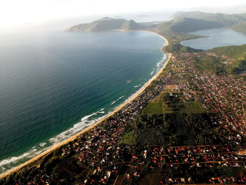
About 41% of the land of Florianópolis is protected territory: 10 municipal areas managed by FLORAM, 3 state (IMA SC), 5 federal (ICMBio). Entrance to municipal parks is free, dogs are not allowed. Swimming in fresh water is possible at Lagoa do Peri: it has the international certificate Bandeira Azul. Camping and a paid ecotrail (R$ 15) are available in Parque Estadual do Rio Vermelho at Praia do Moçambique, phone (48) 3665-4194.
What is allowed and what is not allowed
Dogs are not allowed in the city's protected areas and in the Botanical Garden — this is mandated by the municipal law of 2001. Research, events, trade and filming for commercial purposes — only with permission from the managing authority. FLORAM does not publish entrance fees for municipal parks. Trails, waterfalls and viewpoints inside the parks: see Trails, waterfalls and viewpoints of Florianópolis — length, time, difficulty; fresh water is not guarded by lifeguards in the same way as the sea, see Water and drownings — rip currents, beach flags, what to do.
Lagoa do Peri — Monumento Natural Municipal da Lagoa do Peri
Neighbourhood Armação, map point -27.7265, -48.5090.
The oldest major protected area of the city, 4,274 ha, managed by FLORAM (law 10.530/2019, although the park has existed since 1981). The lake supplies water to more than 100 thousand residents of the south and east of the island. At the headquarters there is a beach where swimming and non-motorized boats are allowed; it has the Bandeira Azul certificate for the 2025/2026 and 2026/2027 seasons. In 2024 the flag was removed after a poor water measurement and returned when the water became suitable again. Trails of varying difficulty, the Morro das Pedras viewpoint, the Sertão do Ribeirão and Porto do Contrato zones. Park phone (48) 3237-5660.
Parque Natural Municipal da Lagoinha do Leste
Neighbourhood Pântano do Sul, map point -27.7728, -48.4927.
921 ha, FLORAM (law 3.701/1992, integrated into the federal system in 2018). Access is only via the trail from Pântano do Sul or Armação or by boat from Pântano do Sul. Morro da Coroa on the southern slope — for the panorama. For the beach, see Beaches of the south of Florianópolis — Campeche, Armação, Matadeiro, Lagoinha do Leste, Naufragados.
Parque Natural Municipal das Dunas da Lagoa da Conceição
Map point -27.6526, -48.4696.
707 ha of dunes between Lagoa da Conceição and the ocean, FLORAM (decree 231/1988, law 10.388/2018). Inside — the lagoons Lagoa Pequena and Lagoa da Chica, the beaches Joaquina and Campeche. Sandboarding on the dunes is allowed. For the beaches, see Beaches on the east of Florianópolis — Moçambique, Barra da Lagoa, Galheta, Praia Mole, Joaquina.
Parque Natural Municipal do Morro da Cruz
Map point -27.5955, -48.5351.
130 ha above the centre, FLORAM (law 6.893/2005, category since 2013). Parking, toilets, an auditorium, sports courts, short trails and viewpoints over the centre and the mainland. Phone (48) 3228-6658.
Parque Natural Municipal do Manguezal do Itacorubi
Neighbourhood Itacorubi, map point -27.5771, -48.5191.
212 ha of mangrove forest in the middle of the city, FLORAM; since 2022 it bears the name of the naturalist Fritz Müller (decree 24.171/2022).
Parque Estadual do Rio Vermelho
Neighbourhood São João do Rio Vermelho, map point -27.5273, -48.4180.
State park of IMA SC, 1,532 ha between Praia do Moçambique and Lagoa da Conceição (decree 308/2007). Entrance to the trails and to Praia do Moçambique is free. An ecotrail with a guide past the animal rehabilitation centre runs Tuesday to Sunday, from 9 to 17, about 50 minutes, mostly on wooden boardwalk; R$ 15, for students, the elderly and locals R$ 7.50, children up to 5 years free. There is IMA camping. A section of the long trail from Barra da Lagoa to the northern edge of Moçambique runs through the park, 18 km, and it is walked in sections.
Estação Ecológica de Carijós
Map point -27.5011, -48.5183.
Federal ecological station of ICMBio, 759.34 ha of mangrove forest of Ratones and Saco Grande (decree 94.656/1987). This is a strict protection category, not a park for walks. Administration address — Rod. SC-402, km 1, phone (48) 3369-0340.
Reserva Extrativista Marinha do Pirajubaé
Neighbourhood Costeira do Pirajubaé, map point -27.6509, -48.5371.
Marine reserve of ICMBio, 1,712.08 ha off the Costeira shoreline (decree 533/1992): here the traditional fishing of local residents is preserved. Phone (48) 3389-2746.
Parque Ecológico do Córrego Grande
Neighbourhood Córrego Grande, map point -27.5998, -48.5140.
A city park of about 21 ha with promenades; dogs are not allowed. Phone 3269-9551. The land is federal, and its transfer to the city was suspended — the status of the dispute should be clarified.
Lagoa da Conceição
Neighbourhood Lagoa da Conceição, map point -27.6260, -48.4840.
A lagoon in the centre of the island, connected by a channel to the ocean at Barra da Lagoa. Its dunes and part of its shores are protected; the lagoon itself is not protected by the city under a separate status. On 25 Jan 2021 a CASAN infiltration pond ruptured, and effluents went into the lagoon; FLORAM created a working group because of this accident. Water quality by points — on the IMA SC website; in the report of 29 Oct 2026 the Lagoa point was unfit for swimming.
Jardim Botânico de Florianópolis
Neighbourhood Itacorubi, map point -27.5796, -48.5077.
Opening hours: Tue–Sun 07:00–18:00. Entrance free.
Projeto TAMAR Florianópolis
Neighbourhood Barra da Lagoa, map point -27.5721, -48.4278.
Opening hours: Mon–Sun 09:30–17:30.
Cachoeira do Monte Verde
Neighbourhood Monte Verde, map point -27.5614, -48.4903.
Waterfall.
Sources
- T1FLORAM — 21 protected areas of Florianópolis: laws, areas, what is allowedpmf.sc.gov.br · primary source
- T1IMA SC — Parque Estadual do Rio Vermelho: decree 308/2007, 1,532 ha, free entry, ecotrail and feesima.sc.gov.br · primary source
- T1IMA SC — Parque Estadual da Serra do Tabuleiro: 84,130 ha, including the south of the island, visitor center in Palhoçaima.sc.gov.br · primary source
- T1ICMBio — Estação Ecológica de Carijós: 759.34 ha, decree 94.656/1987, address and phonegov.br · primary source
- T1ICMBio — Reserva Extrativista Marinha do Pirajubaé: 1,712.08 ha, decree 533/1992gov.br · primary source
- T1FLORAM — phone numbers of the parks Lagoa do Peri, Morro da Cruz and Córrego Grandepmf.sc.gov.br · primary source
- T2NSC Total, 2 Aug 2022 — dogs are not allowed in protected areas and the Botanical Garden under a 2001 municipal lawnsctotal.com.br · secondary source
- T2NSC Total — Blue Flag of Lagoa do Peri beach was removed in 2024 and returned after water measurementsnsctotal.com.br · secondary source
- T2OpenStreetMap and IMA SC — park points on the map, © OpenStreetMap contributors, ODbLopenstreetmap.org · secondary source
- T2openstreetmap.org — location of the place on the mapopenstreetmap.org · secondary source
- T2openstreetmap.org — location of the place on the mapopenstreetmap.org · secondary source
- T2openstreetmap.org — location of the place on the mapopenstreetmap.org · secondary source
T1 — primary: law, agency site, price list. T2 — secondary: press, specialist sites. T3 — other.